Route 1 · 65 km.
El Rodeno
First off we propose the route that is closest to Albarracín, although to cover it fully and without rushing we suggest taking a whole day, and if the weather is on your side, stop to eat at Fuentebuena (for example, buying bread, chops etc. in Albarracín and cooking them there).
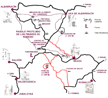
Leave Albarracín through El Arrabal, and after passing through this neighbourhood, set out on a steep road that leads to the Protected Landscape of Los Pinares de Rodeno.
The first examples of rock art can be found at Fuente del Cabrerizo, right at the start of the pine forest, next to some farrowing pens. Park your car on the esplanade next to the houses and take the signposted path between the two houses. To reach the first shelter, you need to go down some steps to the bottom of the ravine. Beforehand, you can admire the contrast of the stone and the Rodeno pine forest from a vantage point (see “panoramic view”). When you reach the bottom, you will see a small spring and the signposted path to cross the ravine. Taking the direction towards Albarracín (path GR-10), which leads to the shelter where you can see some rock engravings (the only ones here) of a deer and an equine animal.
You are now heading to the area with the greatest number of rock art shelters, where there is an information centre. Of these sites, at the very least you should try to visit the shelters at Toricos del Navazo (see “panoramic view”) and the Arquero de los Callejones; the latter is in the Arrastradero area, where also there is a small botanical garden and a viewing point (see “panoramic view”) to Gea de Albarracín, which are worth seeing.
Leave this area and follow the road, taking in the beautiful landscape of pine forests and sandstone, especially around the section that curves to the right where you can admire an impressive sandstone landscape. You will arrive at a crossroads (‘cuatro caminos’) where you need to take a right turn, which takes you to the old forest house, now converted into the Rodeno Visitor Centre, and which is well worth a quick visit. Leaving the Centre, a few metres ahead you will come to another crossroads. Turn right again and after one kilometre you will reach a poplar grove where to the left of the road is the spring (Fuentebuena) and to the right a picnic area with tables and barbecues.
The second part of the tour will take you first to Peña de la Cruz (1,538 m), where you can see some remains of the Civil War and enjoy an excellent view. Leave Fuentebuena on the return trip to Albarracín. Before reaching the last crossroads, turn right onto a dirt road (in good condition) that leads to Tormón. After approximately 2 km you will come to another crossroads with a sign that confirms that on the right the path starts that will take you to the summit (hopefully during the journey you will be able to spot some roe deer). Apart from the fabulous view that you can see from the peak (see “panoramic view”), the sandstone promontory that you have to skirt, which at one point leads you up steps made from the same stone, until you reach the cross and the forest lookout house are equally stunning.
Once back down, on the dirt road, continue in the direction of Tormón (at certain moments, if you look back you can see the Pico de la Cruz peak and its amazing shape). The Bezas lagoon can be reached from two roads (take care with low cars), both signposted. The first route, which is shorter and recommended for off-road vehicles, starts a few metres ahead to the left, although depending on the time of year and the weather conditions (water, ice or snow) it may be difficult to traverse. For the second route, follow the dirt road, until you reach a tarmac road in 4 kilometres. Take a left towards Rubiales, and after some derelict houses you will see a turn signposted on the left indicating the direction via a dirt road which is 2.5 km to Bezas lagoon. Depending on the time of the year that you visit, the lagoon will be filled with more or less water, which originates from the melting ice and rain water, and with more or less quantity of wildlife (ducks, herons, etc.).
To return to Albarracín, you need to return to the previous road and continue in the direction of Rubiales until you reach a crossroads where you can visit another small lagoon formed of melting ice (the Rubiales lagoon). Continue left towards the road that leads to Teruel, and once you arrive at it take the left direction, which passes through Bezas and takes you back to Albarracín.
If you have any time left, turn off the road that goes down from the pine forest to Gea de Albarracín, and you can climb up to another watchtower at Carbonera peak (1,540 m). The uphill road is paved and at the top there is a small space to park your car and to turn around. On one side you can see the whole plain of Teruel and, on the other, the Pinar de Rodeno pine forest. It’s a great view and excellent way to end the excursion.
Additional information
Route length: Approximately 65 kilometres.
Road conditions: local roads, good condition except for a few stretches. Between Fuentebuena and the turn off to Tormón forest dirt road in good condition. The access roads to Bezas lagoon are tracks and you need to be careful as they are not in very good condition (loose stones and potholes).
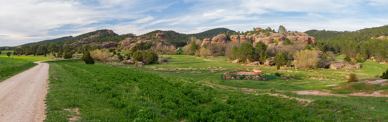
Comments: The Protected Landscape of Los Pinares de Rodeno is located in the south-east of La Sierra de Albarracín. It is an impressive area, consisting of an extensive pine forest on red sandstone from the Triassic period deposited more than 200 million years ago, and whose vibrant colour adopts wine-coloured hues, originating from the lichen colonies that blanket the rocks.
The protected area measures 3,355 ha and runs from 1,095 m of altitude in the Tobias ravine to 1,602 m on the Cruz de Montoyo hill. The wooded area represents seventy percent of the total area. The most important group is the natural Rodeno pine forest, which is situated in the area on reddish conglomerates and sandstones. Other tree varieties here include wild pine, oak, juniper, and varieties of Juniperus thurifera.
The most noteworthy groups of wildlife in this territory are birds and mammals. In the first group, the pine forest is home to small birds such as the wren, the great tit, the coal tit, the robin, the common chaffinch, the short-toed treecreeper and the red crossbill; as well as birds of prey such as the booted eagle, the northern goshawk, the Eurasian sparrowhawk and the Eurasian hobby; and nocturnal birds, like the long-eared owl and the tawny owl. In the oak forest you can spot the Eurasian blue tit, the long-tailed tit, the common blackbird, the common firecrest, the common chiffchaff, the woodlark and the rock bunting, among other species. Rock birds include the golden eagle, the peregrine falcon, the kestrel and the Eurasian eagle-owl. Mammals you can spot here include the squirrel, the hare, the wild boar, the fox and the beech marten.
This singular place, with its towers, corridors, peaks and shelters, was occupied by prehistoric man. Inside the protected landscape is a collection of Levantine rock art recently declared a World Heritage Site. This rock art extends along the Mediterranean border from Catalonia to Andalusia, penetrating inland in the area of Aragón and Castile La Mancha. In 1996, at the initiative of the Valencian Community, the autonomous communities of Aragón, Catalonia, Valencia, Murcia, Andalusia and Castile-La Mancha decided to work together to apply for the Rock Art of the Mediterranean Basin on the Iberian Peninsula to be included in the World Heritage List. The proposal was submitted to the meeting of the Historical Heritage Council on 15 March 1996, and it decided to initiate the inquiry. This agreement marked the beginning, for each of the six communities, of the work necessary to make the proposal to UNESCO.
At the meeting of the World Heritage Committee held in Kyoto from 30 November to 5 December 1998, the group approved including the Rock Art of the Mediterranean Basin on the Iberian Peninsula in the World Heritage List. Among the reasons given for its inclusion are its exclusivity, the documentary value, how it is interwoven into a humanised but highly ecological landscape, and the fragility and vulnerability of these sites.
The declaration affects 757 archaeological sites with rock art and commits the State Administration, six autonomous communities, 163 municipalities and all citizens to the conservation and protection of these sites as, despite being located on our lands, they are now considered universal heritage, a World Heritage Site.
In our area, there are twelve shelters in less than 30 hectares. Since 1982, when E. Marconell discovered the first shelters with Levantine rock art of the Iberian Peninsula in Albarracín, at Prado de los Torinos del Navazo and Cocinilla del Obispo, the group of rock paintings of Albarracín, dated between 6000 – 1500 BC, has distinguished itself from the rest of the representations of Iberian rock art on the peninsula by the use of the colour white, only found in this area, and by the large size of the bovids, their stillness, and for the simplicity in the design of human representations.
Other places of interest:
- Bezas: Levantine rock art, sandstone formations.
- Gea de Albarracín: plains of the Guadalaviar river, traditional architecture.
- Jabaloyas: traditional architecture, Javalón mountain and La Mojada spring.
- Rubiales: sandstone rock formations, pine forest.
- Saldón: juniper thicket and Las Eras well.
- Valdecuenca: Barranco Melero.
Route 2 · 110 km.
Alto Tajo
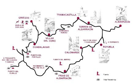
This second route is longer than the first, and is also recommended to do in one day (take a packed lunch or eat at one of the restaurants in Griegos, Guadalaviar, Frias de Albarracín or Calomarde). Leaving Albarracín by the tunnel, in the direction of La Sierra de Albarracín, you will pass through the village of Torres de Albarracín, and then you will arrive at Tramacastilla. Enter the village following the signs for ‘Ruta del Alto Tajo’, continuing along a road that starts to climb.
Before you reach Villar del Cobo you will border the so-called ‘Barranco Hondo’ (deep ravine), and you can clearly see where it takes its name from. Once through Villar del Cobo, follow the road until you reach a crossroads. Turn right to Griegos, the second highest village of Aragón (1,600 m), which is at the foot of the Muela de San Juan, which is 1836 m high and offers cross-country ski slopes.
Returning to the previous crossing, follow the road to Guadalaviar, where the Guadalaviar River starts, which passes through Albarracín and becomes the Turia river in the city of Teruel.
From Guadalaviar the road starts again to climb, until reaching the summit of ‘El Portillo’ (1,790 m), one of the highest points of the Sierra that can be reached by car. Before reaching the summit, on the right there is a path that leads to the watchtower, from where you can enjoy fabulous views of the Tagus valley in its first few kilometres. You can also make a stop at the summit.
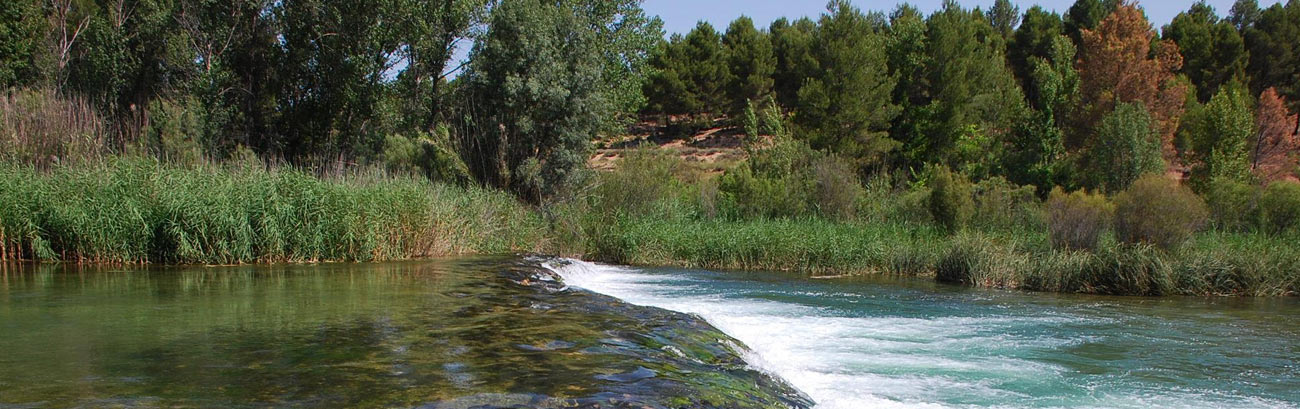
Go down Portillo mountain, the valley road, and once down you will come to a crossing where if you take the road to the right, it ends on a paved road in a small rest area with a spring next to the Tagus river, which we can see with a small flow.
Setting off once again, return by the road, along which you will find a right turn to the Serrania de Cuenca mountains, with highlights including: the source of the Cuervo river, Hosquillo Hunting Ground, el Ventano del Diablo, la Ciudad Encantada, Beteta gorge, Balneario de Solan de Cabras spa… The road leading to Tragacete runs through Puerto del Cubillo, where you can also take in some wonderful views.
If you continue along the previous road you will arrive at the source of the Tagus river, where there is a monument symbolising this source (the Tagus does not really start here).
Back to Albarracín, you will pass through Frias de Albarracín and Calomarde. A few kilometres after passing Calomarde, continuing on the road you will come to a waterfall and shortly after to some small waterfalls that form on La Fuente del Berro river. This is the last interesting stop until you reach Albarracín.
Additional information
Route length: Approximately 110 kilometres.
Road conditions: local roads, in good condition.
Other places of interest:
- Calomarde: ‘El Rollo’ (arch-shaped geological formation due to erosion of calcareous rock), village surroundings between outcrops.
- Frías de Albarracín: village located in a valley, with meadows and pine forests, especially Las Pisadas Mill and ‘El Berro’ spring, Sima, Torrucos (traditional shelter for shepherds).
- Griegos: La Dehesa Boyal between Guadalaviar and Griegos is a splendid landscape formed by extensive meadows among pine trees and patches of scrub.
- Guadalaviar: plains of the Tagus river, bull ring excavated in the rock, Torruco.
- Torres de Albarracín: plains of the Guadalaviar river, vultures gorge.
- Tramacastilla: plains of the Guadalaviar river, springs and Batán del Balsónrecreational space.
- Villar del Cobo: panoramic view from the forest road to Frías, Dolinas, Cobeta spring, El Pu hill, buildings of architectural and cultural interest.
Route 3 · 80 km.
Río Cabriel
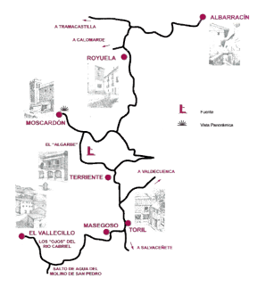
Again leave Albarracín through the tunnel towards the Albarracín mountain range, and after 7 km turn left in the direction of Royuela, and then turn left after 2 km, and again after 8 km, in the direction of Terriente.
After the villages of Toril and Masegoso, follow the road that leads to El Vallecillo.
Before reaching the village you will pass by a small bridge and then a road to the left that takes you to the beautiful waterfall of the San Pedro mill. Back in the car continue towards Vallecillo. At the entrance, to the right there is a path that leads you to Los Ojos del Cabriel.
On the way back to Albarracín, once you have passed Terriente, there is a turning to the left that leads to the recreation and camping area of ‘El Algarbe’, where if you take some chops you can cook them on the barbecue there.
In the afternoon, before returning to Albarracín, you can make a quick visit to the villages of Terriente and Moscardón, which have some remarkable churches.
Additional information
Route length: Approximately 80 km return journey.
Road conditions: local roads, in good condition.
Other places of interest:
- El Vallecillo: La Ubriga cave.
- Moscardón: panoramic view from La Iglesia el Masegar viewing point, monumental European black pine.
- Royuela: juniper thicket, salt flats and La Fuente del Sapo gorge.
Route 4 · 45 km.
Los Castillos
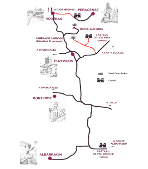
Leave Albarracín on the Teruel road, and after 2 km take a left turn, next to the new industrial estate of Albarracín. Start the climb (carefully on the next 4 km with some curves that have poor visibility) and continue along the narrow road past a small farm until you reach the junction with the road from Cella that goes to Bronchales.
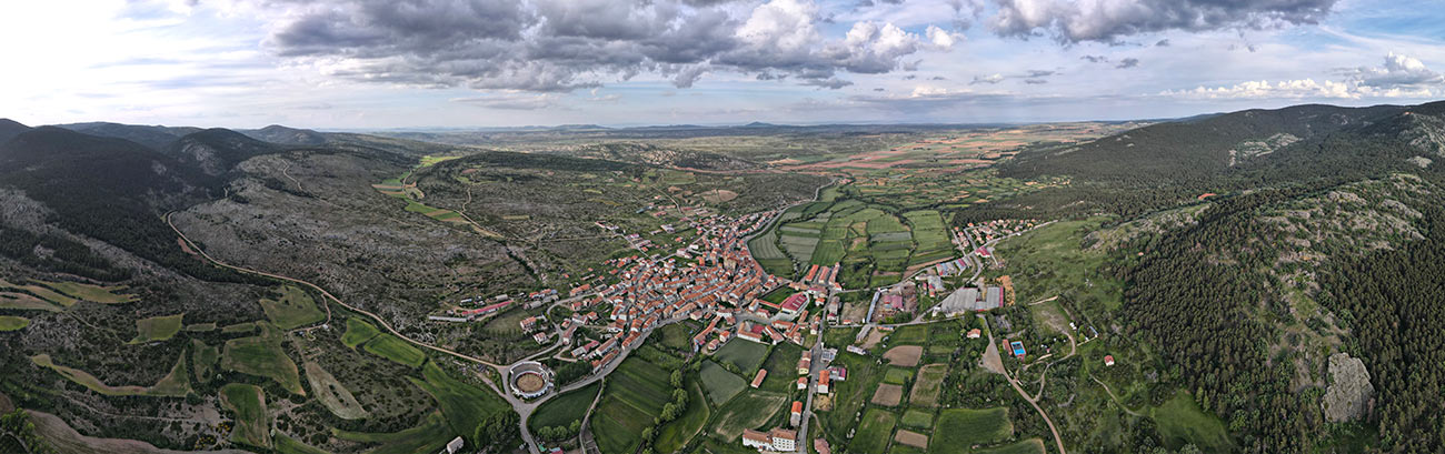
Continue in the direction of Bronchales until after approximately 2 km you find a right turn towards Pozondón. Here is a good place to make a little stop to visit the church with its unique defence tower.
At the exit to the village there is another crossroads; take the direction to Ródenas. At approximately 5 km, there is a right turn to San Ginés mount (1,605 m), which you will have been able to see since before Pozondón and that you can differentiate by its high communications tower at the top. On the mount, you can see, apart from the tower (which you can ‘compare’ with the old one that is still standing), a small chapel and the ruins of a tower, as well as the fantastic view. From here you can easily see the castle of Peracense, which will be your destination.
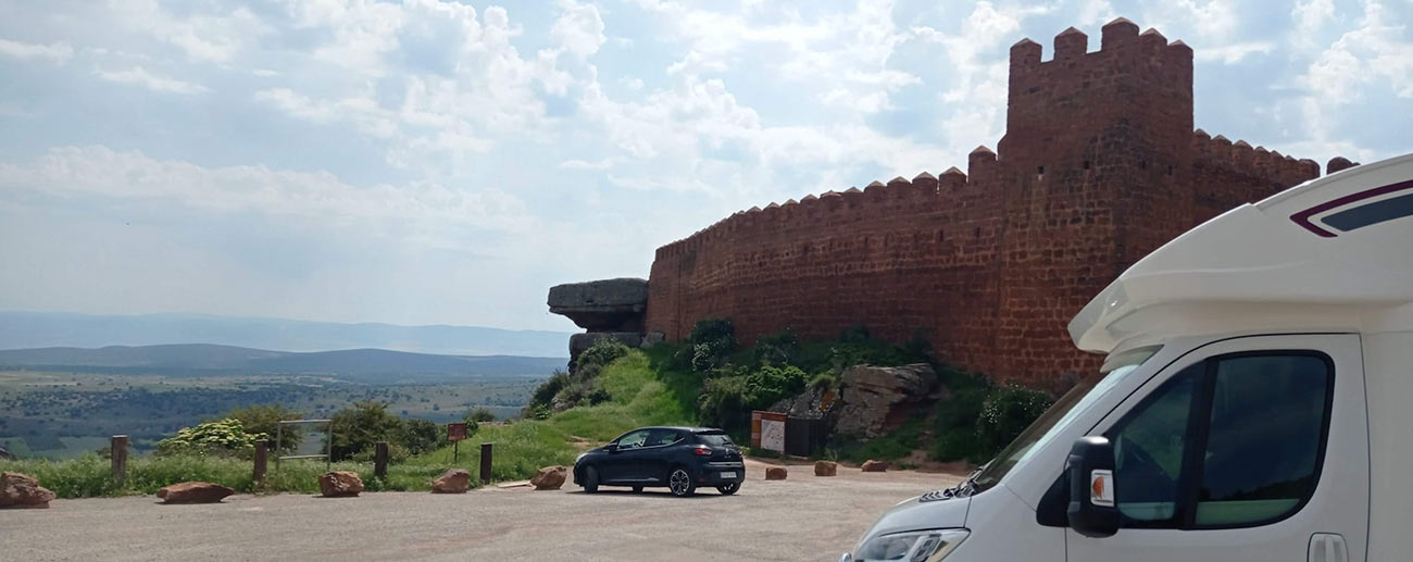
Back on the road, head toward Rodenas and when you arrive at the village you will see a right-hand turn that takes you to the formidable, unique Peracense castle, built from sandstone (see “panoramic views”).
An interesting visit you can do before or after seeing Peracense castle, especially if you have an off-road vehicle (it is also possible with a car if you are careful), is the Cardoso ravine, the sculpture of the ‘Peruvian’, and the ruins of Los Ares castle. Leave Pozondón by the road towards Santa Eulalia and at approximately 1.8 km, just after passing a ‘crash barrier’ on the road, you will see a track on the left that is marked on the ground with yellow and white lines, indicating that it belongs to the hiking path P.R 4. Follow this trail, always keeping the San Ginés peak in front of you. You will begin to descend, with the ruins of the Los Ares castle on the left, until you reach a crossroads. Take the path on the left that is indicated with a wooden sign that says: ‘Esculturas en piedra’ (stone sculptures). In approximately 1.5 km, you will come to a small poplar grove where the road ends and there is a small house in the background, built to be used as a warehouse to store material. Leave the car and start the route on foot, ascending between ravines and red sandstone boulders; in approximately 100 metres, you will reach a curious stone sculpture of an Inca motif which stands almost 7 metres high. This image, known as ‘El Peruano’ (the Peruvian), was made by a native of that country married to a girl from Pozondón.
Heading back, at the fork you left when you saw the sign for the stone inscriptions, if you follow the trail forwards, you will reach the above-mentioned castle ruins. It is built of sandstone, and its most obvious features are the semi-collapsed tower (how is it possible that it is still standing?), and some remains of the walls.
Additional information
Route length: Approximately 45 km to the castle, including the climb up to San Ginés mount.
Road conditions: local roads, in good condition. The road leading to the ‘El Peruano’ sculpture has loose stones and potholes.
Other places of interest:
- Monterde: Valdelagua ravine, rocky rivers in the Monterde mountain and juniper thicket.
- Pozondón: civil architecture.
- Ródenas: cistern and sandstone architecture
Route 5 · 100 km.
Puerto de Orihuela
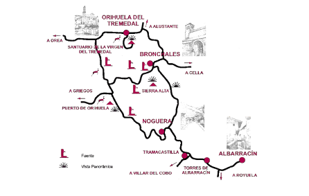
Leave Albarracín through the tunnel in the direction of Orihuela del Tremedal, until you reach Noguera. Before entering the village you will see a detour to the right with a very steep road, which we won’t take, as it will be our return road. Drive through the village and once you have gone past it, a smaller road starts that will take you to Puerto de Orihuela, which is 1,650 m high. From the signpost for the Puerto, you can make out the long straight in the form of a hollow between the pine trees. Once you have arrived in Orihuela del Tremedal, you can see the curious ‘rivers of stone’. Continue along the road without turning off until you reach Orihuela del Tremedal.
Some highlights of its traditional architecture include the 16th-century Town Hall building with a double-arched market, and the House of the Franco Peña de Liria family, with closed picture windows with beautiful wrought iron bars. The religious architecture highlight is its church, the best Baroque work in the entire province of Teruel. Once you have visited the village, it is worth going up to the Sanctuary of la Virgen del Tremedal (1,700 m), where besides the small hermitage you can take in another wonderful view.
You will return along the road you came on and before arriving at the ‘hondo’ (dip) in Puerto de Orihuela, you take a left turn signposted to ‘Fuente del Canto’ spring. Following this road, after passing Fuente del Canto, approximately 6 km away will see a sign on the right indicating ‘Sierra Alta’. The path going up is loose stones, so, depending on your vehicle and enthusiasm, you can leave it parked at the sign and walk up (approximately 2 km), or drive up, carefully. Once at the top, if you have decided to drive, you will see a small picnic area where we can park your car and make the small climb up the hill on foot. The view is fabulous, as you are at 1,856 m, one of the highest summits in the mountain range. In the background you can see the town of Noguera, and according to the forest ranger on the hill you can make out the highest points of seven provinces (Valencia, Castellón, Teruel, Cuenca, Guadalajara, Zaragoza and Soria), that is, from the Sierra de Espadan to the Moncayo.
To return to Albarracín, when you reach the Fuente del Canto road, take the direction towards Bronchales. When the road ends, you will arrive at a crossroads that would take you left to Bronchales or to right to Noguera, to return to Albarracín by the road indicated above.
Due to the length of the route and the places that you will find along the way, it is advisable to spend a full day, allowing you time to stop at a restaurant in Orihuela del Tremedal or Bronchales, or at the springs in Puerto de Orihuela, including the one at the previously mentioned Fuente de Canto, where there is a small restaurant and barbecues for grilling your food (it is also the busiest one).
Additional information
Route length: Approximately 100 km.
Road conditions: local roads, in good condition.
Other places of interest:
- Bronchales: wild pine formation, fauna, springs and recreational areas.
- Noguera: Peña Blanca, Noguera river ravines and gorge.
- Orihuela del Tremedal: Caimodorro (1,935 metres) highest point in the mountain range, which can only be accessed on foot.